I am recently returned from spending a brilliant few days in Gibraltar and Spain and am looking forward to sharing some ‘real time’ posts in the coming weeks.
Day 1 – Arrival and ‘Setting the Scene’
March 19th
Landed in Gibraltar at 17.43, a little later than scheduled, but down to a ‘missing’ passenger at Gatwick, taking his luggage off caused missing our take-off slot. It was a mostly smooth and scenic flight. Snow on Pyrenees in the north-east of Spain, then much of the country veiled by misty cloud, so visibilty for aerial shots not good, but could see the unfolding panorama below well enough. Weather here was still sunny and a balmy 19°C, had been warmer earlier on. I was told I was lucky with the weather. Last week stormy weather and high winds meant most flights in and out were diverted to Malaga.

170319-1743-Landed in Gibraltar- first view of the Rock
Landing in Gibraltar International Airport is always dramatic. Although consistently listed as one of the world’s scariest for air passengers, I can honestly say I have never found it so. Problems arise as the airfield is exposed to strong cross winds around the Rock and across the Bay of Gibraltar/Algeciras, sometimes making landings, particularly in winter, a little uncomfortable and occasionally impossible, but in that event planes are diverted to Malaga to land. The runway is also shorter than many, has the sea at either end and is crossed by the main road into and out of Gibraltar, but under the control of the RAF this is probably one of the most secure and highly scrutinised airstrips in the world too.
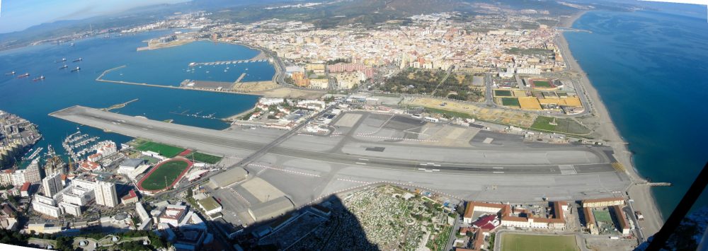
Gibraltar Airport photographed from the top of the Rock

British Airways landing in Gibraltar – heading up runway
Gibraltar is well-known to many as a British Overseas Territory with an ongoing political history of dispute with Spain as to its sovereignty. However, despite features that are recognisibly British, like English signage and language spoken, pubs, red phone and pillar boxes, the Morrison’s supermarket and the Police uniform, this is not a piece of England! Spanish is also widely spoken, they drive on the right and the local cuisine is similar to that of Spain, but it is definitely not Spain either. This is Gibraltar and the majority of the population are Gibraltarian born and bred and rightly proud to be so.
I’ve realised recently that although most people are aware of Gibraltar, easily recognising images of this iconic ‘Rock’, not so many know exactly where in the world it is. My own interest and past involvement with Gibraltar has been, and still is, largely connected with its natural history: the Rock supports a surprisingly rich and diverse fauna and flora, which my next few posts will mostly reflect. It is Gibraltar’s geology and its geological location that makes it such a unique and fascinating place for those interested in natural history: but those factors have also determined and shaped its history, culture, politics and society.
There’s a great deal I didn’t really know myself, so as I was here for a few days I thought I should find out more. Gibraltar has been in the news rather frequenty lately too, in connection with Britain’s ‘Brexit’ from Europe, so I thought it might be interesting to look at how Gibraltar came to have British sovereignty in the first place. I’ve tried to keep it brief, but although a relatively tiny place, there’s an incredible amount packed into it, so forgive me if it goes on a bit.
WHERE Gibraltar IS LOCATED
Geographic coordinates: Latitude: 36°08′41″ N : Longitude: 5°21′09″ W
Elevation above sea level: 11 m = 36 ft
Gibraltar’s terrain consists of the 426-metre-high (1,398 ft) Jurassic limestone Rock of Gibraltar and the narrow coastal lowland surrounding it. Its territory covers 6.7 square kilometres (2.6 sq miles) and shares a 1.2-kilometre (0.75 mile) land border with Spain. It is located on the southern end of the Iberian Peninsula, on the northern side of the Strait of Gibraltar, in Spanish Estrecho de Gibraltar, that run from the Atlantic Ocean to the Mediterranean Sea. This narrow body of water connects the Atlantic Ocean to the Mediterranean Sea and separates Gibraltar and Peninsular Spain in Europe from Morocco and Ceuta (Spain) in Africa. Europe and Africa are separated by 7.7 nautical miles (14.3 km; 8.9 miles) of ocean at the strait’s narrowest point.
Evening approach into Gibraltar from east side with La Linea and Spanish coast
Gibraltar from the air shows its position in relation to Spain. Photographed after take-off, the following photograph shows the West Side of the Rock and the southern tip that points towards North Africa.

The shoreline of Gibraltar measures 12 kilometres (7.5 miles) in length. There are two coasts or ‘sides’ of Gibraltar: the East Side, which contains the settlements of Sandy Bay and Catalan Bay; and the West Side, where the vast majority of the population lives.

The town of La Línea de la Concepción, a municipality of the province of Cádiz, lies on the Spanish side of the border. The Spanish hinterland forms the comarca of Campo de Gibraltar, which translates literally as “Countryside of Gibraltar”.
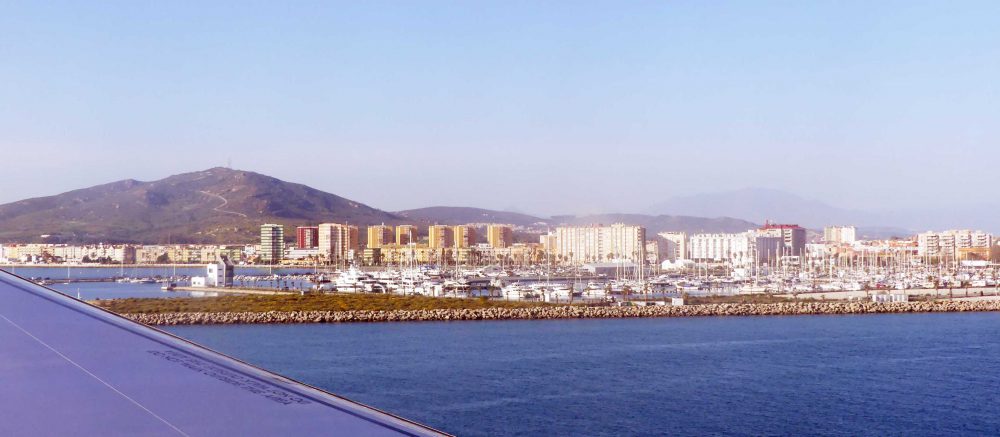
La Línea de la Concepción – the new Harbour
On the opposite, southern side of the Strait lie Morocco and Ceuta, which is a Spanish exclave (a part of a state or territory geographically separated from the main part by surrounding alien territory). Variably visible from Gibraltar, depending on the degree of mist, is the part of the African coastline defined by the Atlas Mountains. The Straits are just 14 kilometres wide at this point and a hazardous place to be due to the immensely strong currents.
TERRITORIAL WATERS
The Strait lies mostly within the territorial waters of Spain and Morocco, except for at the far eastern end. The United Kingdom (through Gibraltar) claims 3 nautical miles around Gibraltar putting part of the Strait inside British territorial waters, which then means that part of the Strait therefore lies in international waters according to the British claim. However, as we are aware, the ownership of Gibraltar and its territorial waters is disputed by Spain, and similarly Morocco dispute the far eastern end (of Ceuta), which is owned by Spain. It’s complicated.

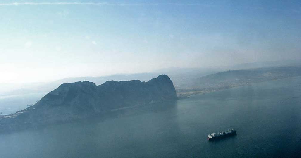
Across the Strait to Ceuta and Jebel Musa from Gibraltar
The highest point of this photograph is Jebel Musa, which is 851 metres high and located five kilometres west of Ceuta in Morocco to the south. Together with the much smaller Rock of Gibraltar at just 426 metres, these two mountains guard the entrance exit to the Atlantic Ocean from the Mediterranean Sea and form the Pillars of Hercules.
GIBRALTAR FROM OTHER ANGLES
The distinctive Rock is visible from miles away. Often shrouded in mist, its unmistakable bulk can still be readily identified from many locations along the Spanish coast and particularly from the vantage point of mountains that have views to the south, all of which help to place it in the wider landscape.
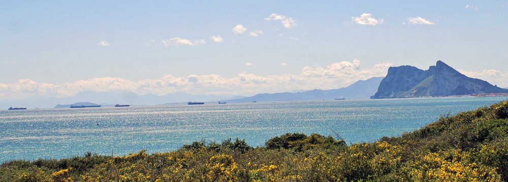
Gibraltar seen from Alcaidesa on the Spanish coast east of La Linea

Gibraltar from alongside the Strait to the west of the Rock

View to Gibraltar from the summit of El Bujeo across the town of Algeciras
A Brief History of Gibraltar
Ancient times

View of the northern face of the Moorish Castle’s Tower of Homage. Built in the 14th century.
It is a unique and fascinating place historically and culturally. In ancient history its strategic geographical position on the northern boundary of the Strait of Gibraltar saw it occupied and influenced in turn by Neanderthals, Phoenicians, Carthaginians, Romans, Vandals, Visigoths and most pronouncedly by the Moors. The name Rock of Gibraltar originates from the Arabic Jebel Tariq, meaning “Tariq’s mountain” was named after Tariq ibn Ziyad.
How Gibraltar became ‘British’
In 1462 Gibraltar was finally captured by the Spanish Juan Alonso de Guzmán, 1st Duke of Medina Sidonia. There was some to-ing and fro-ing of control amongst the Spanish themselves, but it remained Spanish until 1704, when during the War of the Spanish Succession, a combined Anglo-Dutch fleet, representing the Grand Alliance, captured the town of Gibraltar on behalf of the Archduke Charles of Austria in his bid to become King of Spain. In 1713 the Treaty of Utrecht ceded control of Gibraltar to Britain ” in perpetuity”, to secure Britain’s withdrawal from the war. Unsuccessful attempts by Spanish monarchs to regain Gibraltar were made with the siege of 1727 and again with the Great Siege of Gibraltar (1779 to 1783), during the American War of Independence.
Britain’s interest in Gibraltar historically has been a military one. It became a key base for the British Royal Navy, playing an important role prior to the Battle of Trafalgar (21 October 1805) and during the Crimean War of 1854–56, due to its strategic location. Its strategic value increased when the Suez Canal opened, as it lay on the sea route between the UK and the British Empire east of Suez. In the later 19th century, there were major investments in improving the fortifications and the port. During World War II it was an important base for the Royal Navy as it controlled the entrance and exit to the Mediterranean Sea, which is only eight miles (13 km) wide here. It remains strategically important to this day with half the world’s seaborne trade passing through the Strait.
Present Day Gibraltar
The last UK-based army battalion left Gibraltar in 1991 and the Royal Gibraltar Regiment took charge of local defence under the command structure British Forces Gibraltar. Today Gibraltar is used primarily as a training area for the British Armed Forces, due to its good climate and rocky terrain, and as a stopover for aircraft and ships en route to and from deployments East of Suez or Africa. (More information on British Forces Gibraltar )
Today Gibraltar’s economy is based largely on tourism, online gambling, financial services, and shipping. The sovereignty of Gibraltar is a major point of contention in Anglo-Spanish relations as Spain asserts a claim to the territory. Gibraltarians overwhelmingly rejected proposals for Spanish sovereignty in a 1967 referendum and again in 2002. Under the Gibraltar Constitution of 2006, Gibraltar governs its own affairs, though some powers, such as defence and foreign relations, remain the responsibility of the British government.
We can only wonder what the future has in store for this iconic Rock, but whatever may happen politically and historically as a result of our human wrangles and power struggles, let us hope that its wonderful wildlife continues to survive and thrive.
___________________________________________
All photographs are my own. Other references include: Wikipaedia (various) and The Rock from Bottom to Top by Nick Nutter ISBN-13: 978-1530659449